
Provided by: mapserver-bin_7.4.3-2build1_amd64 
NAME
tile4ms - create a tile index Shape data set for use with MapServer's TILEINDEX feature
SYNOPSIS
tile4ms [ metafile tilefile [-tile-path-only] | -h]
DESCRIPTION
       tile4ms  creates  a  tile  index  Shape  data set for use with MapServer's TILEINDEX feature. The program
       creates a Shape data set of rectangles from extents of all the Shape data sets listed  in  metafile  (one
       Shape  data  set  name per line) and the associated DBF with the filename for each shape tile in a column
       called LOCATION as required by mapserv.

       Note: Similar functionality can be found in the GDAL commandline utilities ogrtindex ⟨http://
       www.gdal.org/ogrtindex.html⟩  (for  vectors)  and  gdaltindex  ⟨http://www.gdal.org/gdaltindex.html⟩ (for
       rasters).

       tile4ms creates a Shape data set containing the MBR (minimum bounding rectangle) of  all  shapes  in  the
       files provided, which can then be used in the LAYER object's TILEINDEX parameter of the mapfile.  The new
       filed created with this command is used by MapServer to only load the files associated with  that  extent
       (or tile).
OPTIONS
       metafile
              INPUT file containing list of shapefile names.  (complete paths 255 chars max, no extension)

       tilefile
              OUTPUT shape file of extent rectangles and names of tiles in tilefile.dbf

       -tile-path-only
              Optional  flag.  If specified then only the path to the shape files will be stored in the LOCATION
              field instead of storing the full filename.

       -h     Display usage information
EXAMPLE
Short Example
Create tileindex.shp for all tiles under the /path/to/data directory:
cd /path/to/data
find . -name "/*.shp" -print > metafile.txt
tile4ms metafile.txt tileindex
Long Example
This example uses TIGER Census data, where the data contains files divided up by county (in fact there
are over 3200 counties, a very large dataset indeed). In this example we will show how to display all
lakes for the state of Minnesota. (note that here we have already converted the TIGER data into Shape
format, but you could keep the data in TIGER format and use the ogrtindex utility instead) The TIGER
Census data for Minnesota is made up of 87 different counties, each containing its own lakes file
('wp.shp').
1. We need to create the 'meta-file' for the tile4ms command. This is a text file of the paths to all
'wp.shp' files for the MN state. To create this file we can use a few simple commands:
find -name *wp.shp -print > wp_list.txt
The newly created file might look like the following (after removing the full path):
001\wp.shp
003\wp.shp
005\wp.shp
007\wp.shp
009\wp.shp
011\wp.shp
013\wp.shp
015\wp.shp
017\wp.shp
019\wp.shp
...
2. Execute the tile4ms command with the newly created meta-file to create the index file:
tile4ms wp_list.txt index
Processed 87 of 87 files
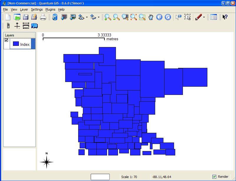
3. A new file named 'index.shp' is created. This is the index file with the MBRs of all 'wp.shp' files
for the entire state, as shown in Figure 1. The attribute table of this file contains a field named
'LOCATION', that contains the path to each 'wp.shp file', as shown in Figure 2.
Figure 1: Index file created by tile4ms utility ⟨http://mapserver.org/_images/tile4ms-view.png⟩
Figure 2: Attributes of index file created by tile4ms utility ⟨http://mapserver.org/_images/
tile4ms-attributes.png⟩
4. The final step is to use this in your mapfile.
• LAYER object's TILEINDEX - must point to the location of the index file
• LAYER object's TILEITEM - specify the name of the field in the index file containing the paths
(default is 'location')
• do not need to use the LAYER's DATA parameter
For example:
LAYER
NAME 'mn-lakes'
STATUS ON
TILEINDEX "index"
TILEITEM "location"
TYPE POLYGON
CLASS
NAME "mn-lakes"
STYLE
COLOR 0 0 255
END
END
END
When you view the layer in a MapServer application, you will notice that when you are zoomed into a small
area of the state only those lakes layers are loaded, which speeds up the application.
SEE ALSO
       shp2img(1), shptree(1), shptreetst(1), shptreevis(1), sortshp(1)

                                                28 February 2020                                      tile4ms(1)